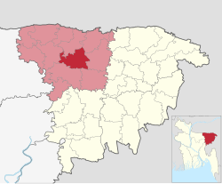
Shantiganj Upazila
Shantiganj
শান্তিগঞ্জ | |
|---|---|
 Pagla Mosque, Shantiganj | |
 | |
| Country | |
| Division | Sylhet |
| District | Sunamganj |
| South Sunamganj | 2006 |
| Shantiganj | 2021 |
| Government | |
| • Upazila Chairman | Faruq Ahmad |
| • MP (Sunamganj-3) | Muhammad Abdul Mannan |
| Area | |
| • Total | 303.17 km2 (117.05 sq mi) |
| Population | |
| • Total | 204,998 |
| • Density | 680/km2 (1,800/sq mi) |
| Demonym | Shantiganji |
| Time zone | UTC+6 (BST) |
| Postal code | 3001 (Pagla)[2] |
| Postal code | 3002 (Patharia)[2] |
| Website | southsunamganj |
Shantiganj (Bengali: শান্তিগঞ্জ, romanized: Shantigônj, formerly known as South Sunamganj or Dakshin Sunamganj (Bengali: দক্ষিণ সুনামগঞ্জ, is an upazila of the Sunamganj District in Sylhet Division, Bangladesh.[3]
Geography
[edit]
Shantiganj is located in between 24°49' and 25°10' north latitudes and in between 91°14' and 91°27' east longitudes. It has a total area of 303.17 square kilometres (117.05 sq mi). The Surma River and Kalni River flow through Shantiganj. The Ufa, Karchabarar, Saladia, Behala, Baradal and Basadubi beels are other notable bodies of water in Shantiganj, in addition to the Dekhar haor. The upazila is bounded by Chhatak Upazila and Dowarabazar Upazila to the east, Derai Upazila and Jagannathpur Upazila to its south, Jamalganj Upazila to its west, and Sunamganj Sadar Upazila to its north.
History
[edit]Shantiganj was first established as an upazila on 6 June 2006 when it was separated from Sunamganj Sadar Upazila and given the name "South Sunamganj".[4] On 26 July 2021, Khandker Anwarul Islam announced the renaming of South Sunamganj to "Shantiganj".[5]
Demographics
[edit]According to the 2011 Census of Bangladesh, Shantiganj Upazila had 32,033 households and a population of 183,881. 56,643 (30.80%) were under 10 years of age. Shantiganj had a literacy rate (age 7 and over) of 32.30%, compared to the national average of 51.8%, and a sex ratio of 1021 females per 1000 males. 5,181 (2.82%) lived in urban areas.[4][7]
With over 32,000 households, majority (80.6%) of these are kancha or kucha houses which are made from mud or clay, while a few are semi or full pucca houses. A small minority of these houses have access to sanitary latrine (29.2%), majority have non-sanitary latrine (60.4%) and 10.4% do not have toilet facilities available. Electricity within the upazila was available to 38.4% of the population.[4]
The population is predominantly Muslim (90.3%) with a small minority of Hindus (9.7%) and very few following other religions.[4]
Education
[edit]The literacy rate and school attendance is below average of the Sunamganj District, with 32.30% and 43.8% respectively.[4] There are five madrasas in the upazila, including Jamia Islamia Haji Akram Ali Dakhil Madrasa and Amaria Islamia Alim Madrasa.
Administration
[edit]Shantiganj Upazila is divided into eight union parishads: Dargapasha, Joykalash, Paschim Birgaon, Paschim Pagla, Patharia, Purba Birgoan, Purba Pagla, and Shimulbak. The union parishads are subdivided into 102 mauzas and 171 villages.[4]
Chairmen
[edit]| Name | Term | Party |
|---|---|---|
| Abul Kalam | 2018 | Awami League |
| Faruq Ahmad | 2019-present | Independent (formerly Bangladesh Nationalist Party) |
Economy and tourism
[edit]There are 15 haat bazaars in Shantiganj. These are: Patharia Bazar, Pagla Bazar, Noakhali Bazar, Ganiganj Bazar, Birgaon Bazar, Taila Bazar, Natun Bangla Bazar, Aktapara Bazar, Damodharatapi Bazar, Chikarkandi Bazar, Muradpur Bazar, Jaikalas Bazar, Thakurbhog Bazar, Shantiganj Bazar and Bhamabhami Bazar.[9]
Shantiganj Upazila is home to around 150 mosques, most notable of which is the historic Pagla Jame Mosque.
Notable people
[edit]- Muhammad Abdul Mannan, minister, diplomat and bureaucrat
- Faruk Rashid Chowdhury, communist
- Humayun Rashid Choudhury, diplomat and politician
- Shamsun Nahar Begum, former Member of Parliament
References
[edit]- ^ National Report (PDF). Population and Housing Census 2022. Vol. 1. Dhaka: Bangladesh Bureau of Statistics. November 2023. p. 404. ISBN 978-9844752016.
- ^ a b "Bangladesh Postal Code". Dhaka: Bangladesh Postal Department under the Department of Posts and Telecommunications of the Ministry of Posts, Telecommunications and Information Technology of the People's Republic of Bangladesh. 20 October 2024.
- ^ Sirajul Islam; Miah, Sajahan; Khanam, Mahfuza; Ahmed, Sabbir, eds. (2012). "Dakshin Sunamganj Upazila". Banglapedia: the National Encyclopedia of Bangladesh (Online ed.). Dhaka, Bangladesh: Banglapedia Trust, Asiatic Society of Bangladesh. ISBN 984-32-0576-6. OCLC 52727562. OL 30677644M. Retrieved 31 October 2024.
- ^ a b c d e f "Bangladesh Population and Housing Census 2011 Zila Report – Sunamganj" (PDF). bbs.gov.bd. Bangladesh Bureau of Statistics.
- ^ "Three new upazilas in Madaripur, Cox's Bazar and Sunamganj". Dhaka Tribune. 26 July 2021.
- ^ Population and Housing Census 2022 - District Report: Sunamganj (PDF). District Series. Dhaka: Bangladesh Bureau of Statistics. June 2024. ISBN 978-984-475-222-1.
- ^ "Community Tables: Sunamganj district" (PDF). bbs.gov.bd. Bangladesh Bureau of Statistics. 2011.
- ^ Ahmad, Husayn (10 March 2019). দক্ষিণ সুনামগঞ্জে স্বতন্ত্র ফারুক আহমদ চেয়ারম্যান পদে বিজয়ী (in Bengali).
- ^ হাটবাজার [Hatbajar]. Dakshin Sunamganj Upazila (in Bengali).

